I love maps. Love them, love them, love them. For me, genealogy is the perfect blend of many things I love: playing detective to solve mysteries and find the truth of a situation, organizing information so that the big picture is as understandable as the small detail, making cold calls to third cousins who have never heard of me, translating text from foreign languages into English, and spending hours poring over maps. I enjoy genealogy the most when it’s a good balance of show-and-tell, rich with old photos, vintage postcards, maps, and other illustrations that make names and dates come alive.
A photograph captures a moment in time. A postcard preserves a landscape, a building, a passenger ship that may no longer exist. A map identifies exactly where on Planet Earth a family lived hundreds of years ago, thousands of miles away across an ocean. All these images carry enormous power. To me, they’re just plain magical. When I find a family village on a map and touch that place-name on that piece of paper (or stare at it on my computer screen), I feel like I am touching all the generations of my family who lived there. (In the interest of full personal disclosure here, I should note that if I could have one wish—excluding, of course, world peace—it would be time travel.)
Over the past 13 years, I’ve collected a variety of maps that illustrate the geographic area my Prokopowicz families have called home for hundreds of years. It is the Lida region in today’s western Belarus, populated predominantly by ethnic Poles. This territory at various times in history has been part of the Polish-Lithuanian Commonwealth, part of the Russian Empire, part of the Second Polish Republic, part of the Union of Soviet Socialist Republics. Depending on the era, maps may label this region Bialorus, Wilno gubernia, wojewodztwo wilenskie, wojewodztwo nowogrodskie, Byelorussia, Belarus. Many Poles still refer to it as part of the kresy, Poland’s eastern borderlands. The most detailed maps of the Lida area—the ones that identify even the smallest villages and hamlets—were created in Polish, German, and Russian. Since this area today shares borders with Poland and Lithuania, villages along the “frontier” are sometimes included in Lithuanian maps as well.
Coming next: Some maps of the Lida area. (A current map of Belarus and a map of Partitioned Poland are among my August 17 posts.)
Home in Kozarezy

At the Ellis Island bookstore
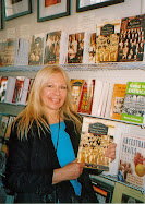
During my visit to Ellis Island in 2005, I was thrilled to discover that the bookstore carries the Polish community books I have coauthored for Arcadia Publishing. On display here is The Polish Community of New Britain.
About Me

- Basia
- I am descended from two apparently unrelated Prokopowicz families with Polish Roman Catholic roots in the Lida area of what is now western Belarus (at one time Wilno gubernia of Russian Poland). My grandparents immigrated to the United States before World War I and settled in Worcester, Massachusetts, where I grew up. I am a journalist and the lead coauthor of The Polish Community of Worcester (Arcadia, 2003) and Worcester County's Polish Community (Arcadia, 2007). Active in genealogy since 1996, I am a member of several genealogical societies and the founder/moderator of the PolishMass Yahoo! Group. I conduct presentations on Polish genealogy, documenting local and family heritage through vintage images, and the history of Polish settlement in Massachusetts. I have traveled to Poland, Belarus, and Lithuania to visit my ancestral villages and meet long-lost cousins. If I could time-travel, I would go back to Lida powiat to meet my great-grandparents and earlier ancestors.

Subscribe To Basia's Polish Family


Basia's Polish Family: Wilno > Worcester by Barbara Proko is licensed under a Creative Commons Attribution-Noncommercial-No Derivative Works 3.0 United States License.
No comments:
Post a Comment